Monday, 30 December 2019

The Cuckoo Stone


The Cuckoo Stone is a fairly modest standing stone around a mile from Stonehenge. The sarsen is one of many which once littered the landscape, left here long ago by glacial action, and the stone was simply raised in its original, natural location. It has long since fallen again. 
A pit near the stone contained cattle bone, flint, pottery and an antler pick, perhaps the tools used to raise the stone and the subsequent feast to consecrate it. The pick dates to 2900BC, the earliest phase of Stonehenge which at this point comprised a circle of bluestones but none of the huge sarsens.


Bronze Age burial urn from the Stonehenge area.

The Cuckoo Stone remained a revered site for the next three thousand years. Several Bronze Age cremation urns were interred around the stone, with dates ranging from 2000BC to 1260BC. Much later still, a Roman-era village with large farms and a wide spread of fields grew up around the stone, and burials from this period were inserted into a Bronze Age barrow a short distance away near Woodhenge. Almost certainly this village was the home of people whose ancestry stretched back to the Neolithic and Bronze Age inhabitants of the area, despite their adaptation of Roman ways in the early centuries CE, and they were successors to the ancient traditions of the still-sacred Stonehenge landscape.


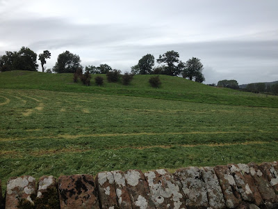
The Cuckoo Stone looking towards Woodhenge

Why was the Cuckoo Stone so important? It lies on gently sloping grassland on the eastern edge of Salisbury Plain, with wide views in all directions but the west, where Stonehenge itself is hidden by the slope. The stone is on the same alignment as the Stonehenge Cursus, an enigmatic ditched enclosure 3km long and 100m wide, which seems to commemorate an ancient routeway. This route, and perhaps the cursus if it had been continued, would have incorporated the Cuckoo Stone, at the time recumbent but eventually raised, and continued to Woodhenge a few hundred metres to the east.

We will probably never know the reason for the importance of this alignment of natural features, but they remained respected in people’s memories as the Neolithic was succeeded by the Bronze Age, as Celts and then Romans swept across Britain and the country’s way of life changed beyond recognition, again and again. Eventually the Cuckoo Stone succumbed and became a mere rock in a field, but thanks to recent archaeology, its importance has been rediscovered.

Monday, 16 December 2019

The Burton Dassett Hills


The Burton Dassett Hills in Warwickshire lie just north of the Edgehill ridge, along the course of an ancient routeway which passes sites such as the Rollright Stones, and are associated with a range of strange phenomena.

The hills are a beautiful place with wide views across the countryside in all directions, and have a particularly powerful atmosphere which most visitors consciously or unconsciously sense and draws them back over and again. Ley hunters attest to a powerful current of earth energy flowing through the area.


The view from Bonfire Hill


The hills have long been associated with fiery apparitions, once identified as angels or saints, and in more scientific times as geoplasma or earthlights, which appear as person-sized orbs or columns of light in darkness or as misty clouds in daylight. These apparitions float across the ground, spiral into the sky, and can disturbingly set fire to wooden buildings. Their appearance clusters around periods of heavy rain, and scientists believe the ironstone bedrock combined with underground flowing water creates the phenomena.


Burton Dassett Holy Well


The hills in Roman times were known as the Phoenix Hills, a legendary bird born of fire, which perhaps links to their eerie apparitions. The northernmost hill, Bonfire Hill, was the site of Twelfth Night bonfires in the Middle Ages and was perhaps used as a beacon site long into pre-Christian times. Surprisingly, there are no remains of any prehistoric settlement or ritual sites on the hills, although it certainly seems as if the hills were of special significance.


Some of the stone carvings in the church


A holy well – where an orb of geoplasma once appeared and set light to a gatepost – and a Medieval church known as the ‘cathedral in the hills’ stand beside the ancient route to the hills. The church is popularly described as an especially powerful location, and its pillars are adorned with intriguing carvings including a green man, a winged beast with a human face, a fighting dragon and lion, and other more ordinary animals. Some people would link them to the hills’ tradition of fiery apparitions, but their explanation remains a mystery.  


Monday, 2 December 2019

Woodhenge


Woodhenge looking from the entrance. The remains of the ditch are visible.


Woodhenge was a timber monument built on Salisbury Plain and a key part of the Stonehenge complex. Nothing now remains except concrete markers denoting the wooden posts. It has no alignment or view of Stonehenge itself, but it lies around half a mile from the Stonehenge Cursus, following the same alignment, suggesting the two monuments were (or were to have been?) linked. It also overlooks the vast henge of Durrington Walls and would have been clearly visible beyond the henge banks.


Woodhenge is on the edge of a prominent ledge of the plain, which drops away to the south and east and has far-reaching views. It would also have been clearly visible dominating the high horizon. It comprised six concentric circles of timber posts, reminiscent of the timber circles in Durrington Walls itself. The posts, ranging from fairly modest trees to substantial mature trees, were raised then left to decay. The outer circle comprised small, closely placed posts; then two circles of increasingly larger posts; then three inner circles of smaller posts. The monument was enclosed by a circular ditch and bank with an entrance facing north-west, towards the midsummer sunset.

The Stonehenge tenon joints which may represent experience in timber-building.


Unlike stone-built monuments, it is impossible to know what Woodhenge looked like. The tree trunks may have been left with bark and perhaps branches, resembling an artificial forest or wilderness. They may have been stripped and decorated, or had ritual offerings pinned to them. They may have had horizontal lintels, rather like Stonehenge itself. One point supporting this is the rounded mortice-tenon joints on Stonehenge’s sarsens, added to stop the lintels slipping free. The weight of the stone, in hindsight, made this unnecessary, so were the builders using their experience of building timber-lintelled structures, where these precautions were essential? It may be that all these ideas were incorporated into the timber circles: perhaps a lintelled enclosure contained a microcosm of the forested wilderness which children feared and adults were forced to learn to master.


The Woodhenge posts date to around 2500BC, the time Stonehenge was radically restructured, but like many monuments Woodhenge had a much longer heritage, which began as veneration of a natural feature. Four standing stones once formed a three-sided cove in the southern part of the monument. These had been raised around a tree throw-hole: a huge mature tree had once stood here, perhaps long venerated by the local people, and when it fell the stones were raised to commemorate it. Pottery and flints placed in the hole date to around 3800BC, over a millennium before the timber circles were raised.


The cairn in the centre of Woodhenge


A child’s burial was found at the centre of the timber circles, its location now marked by a cairn. It is often stated that this was a sacrifice to consecrate the monument, but many archaeologists now refute this. The burial was probably in fact from the Bronze Age, long after the site had decayed into a mass of rotten stumps and fallen logs, and the skull damage, once attributed to an executioner’s axe, was probably simply damage from 4000 years in the ground.


Today Woodhenge is little known and little visited. Perhaps the concrete posts which are its sole survival tell us the message it was built to convey, five millennia ago. Even the most enduring of life will decay and vanish, and nobody will ever know it was there.

Monday, 25 November 2019

The Red Horse of Tysoe


A reconstruction of the horse.


This probably ancient hill figure has been long destroyed, but it may once have had significance equal to the White Horse of Uffington. Today it survives only in local place names and business names.

The horse was cut into the steep escarpment of Edgehill in Warwickshire, a ridgeline of high ground which formed part of the long-distance ancient routeway which linked places such as the Rollright Stones, Traitor’s Ford and the Burton Dassett Hills. The area has an ancient spiritual heritage and is linked to ghostly phenomena.


The ancient routeway along Edgehill


The horse was formed of trenches cut into the clay subsoil and filled with a bright red, iron oxide-rich silt which is characteristic of the area and gave the figure its name. The horse, like the hill figure at Uffington, was intended to command the vast plain below the escarpment, which stretches to the west for several miles. From any point in the vale, the escarpment is visible on the horizon and the now vanished hill figure would have drawn the eye. It was a declaration to anyone who passed by.


The view over the Vale of the Red Horse


Unlike other monuments, hill figures are dependent on human agency for their survival. A few years of neglect and they vanish forever. It is also human agency which determines whether they retain their original outline or whether they are altered or improved according to the whim of the scourers. Or maybe this was the intention? So many ancient monuments, Stonehenge being a prime example, are now known to have been constantly modified and rearranged. Perhaps hill figures too were about the process of creation and recreation, and each successive generation added their own stamp to it?


A 19th century recording of the horse


The first record of the horse’s presence dates to 1612, and local records from the 1640s state it was scoured every year. It seems it was much redefined over the centuries. The final version, ploughed up and destroyed in 1800, was a rather inferior design with a tail resembling a lion’s. A 20th century investigation found evidence of this horse on the hillside, a little way above two other hill figures which it probably replaced.

The older figure was a galloping horse, 91 metres in length, with a smaller figure, probably a foal, in front of it. These were long grassed over by the 19th century. The date of its construction is unknown, but it’s been suggested that, like the Uffington Horse, it dates to the Bronze Age. The horse became a symbol of power in the warrior societies of this time, and it features strongly in local legends such as Lady Godiva and the lady of Banbury Cross, perhaps part-forgotten memories of religious rites involving a woman (or Goddess) on horseback. The hill figure may have represented this deity, and proclaimed its might over the vast area it overlooked.

Another interesting point is the name of the nearby village. Tysoe derives from Tiw’s hoe; the hillside of Tiw. Tiw, or Tyr, was the Anglo-Saxon and Scandinavian God of warriors who gives his name to Tuesday. Was this hillside dedicated to Tiw by Anglo-Saxon settlers who found an already ancient and sacred figure on this hillside? It seems likely.

The escarpment looking down towards Tysoe


Monday, 11 November 2019

The Stonehenge Great Cursus


 The western end of the cursus.


The cursus is a strange and enigmatic structure, unique to British prehistory, and with a purpose which still eludes archaeologists.

Cursuses are ditched and banked enclosures, around 100m wide and extending for several kilometres across the landscape. Their shape gave rise to their name: an early suggestion, now refuted, was that they were racecourses.

The Stonehenge Cursus is three kilometres long and 100-150m in width, and stretches east-west across the plain a few hundred metres north of Stonehenge. It was built in the early Neolithic period, between 3600-3300BC, several hundred years before Stonehenge itself was begun, and is perhaps the oldest creation in the Stonehenge complex.


The location of the Lesser Cursus.


A second cursus was also built to the north, 60m wide and 400m in length, along a ridgeline which has a commanding position over the surrounding area. It had been extended at some point, and the fact that it simply stops at its eastern end suggests it may not have been finished.

The eastern end of the Great Cursus was formed by a now-ruined long barrow which dates to a broadly similar time, although it is unclear whether it was built before, after, or at the same time as the cursus. Many cursuses incorporate long barrows and other ritual structures.

It’s possible that this cursus too was unfinished, and the long barrow was simply a convenient ‘stop’. It’s also possible that they were never intended to be ‘finished’: they were simply extended continuously according to rules we can only guess at, rather like Stonehenge itself and the nearby timber monuments were continually remodelled. It’s becoming more and more apparent that the process of creating monuments was more important to our prehistoric ancestors than the finished structure itself.

Supporting this theory is the Cuckoo Stone, a standing stone which became a shrine a few hundred metres from the ‘end’ of the cursus and on the exact same alignment. Perhaps this would have in time been incorporated into the cursus. Further on the same alignment is Woodhenge, another standing stone called the Bulford Stone, and then the prominent Beacon Hill. Surely this cannot all be coincidence?


The view east along the cursus. The ditch aligns on the distant Beacon Hill.


The most accepted explanation for cursuses is commemoration and movement: perhaps they were a memorial of a processional way or a corpse road or spirit road. This could explain why many are linked to long barrows. Cursuses in other places seem to be transferring power from an older ritual monument to a newer one.

The Stonehenge Cursus begins at its western end on a ridgeline, which offers views in all directions, then rapidly drops to eventually reach Stonehenge Bottom, once a watercourse. The hillside quickly obscures the view behind, leaving the walker with nothing but the route ahead which remains visible, with the cursus ditch aligned on the distant Beacon Hill, until the midpoint when that too is swallowed.


The view behind is swallowed up as the traveller journeys east.


In the bowl of the valley, nothing remains of the outside world and the journeyer is left with a sense of isolation and disconnection. Was this a key part of this symbolic journey? Were people, perhaps the living or perhaps the dead, ritually and spiritually scoured clean here, aided by the flowing spring water, before continuing their journey back into the world? From this point, the walker climbs up the opposite slope, the views of the plain reappear, and the high point of the ridge appears where the long barrow stood and the cursus ends. A long journey is complete.

Monday, 4 November 2019

Durrington Walls


Reconstruction of Durrington Walls, showing the avenue, river, and timber circle.


Durrington Walls, found two miles from Stonehenge, is one of the greatest henge monuments in Britain, and part of the vast religious complex which stretches across the chalklands of Salisbury Plain.

The henge today survives as a chalk bank, originally three metres high and over a mile long, enclosing an area of 42 acres, with an internal ditch 16 metres wide and six metres deep. This vast earthwork enclosed a huge settlement, with up to a thousand wattle and chalk houses divided into discrete communities. The ditch and bank were dug around 2500BC, destroying many of the outer houses, and is linked to the increasing elaboration and enclosure of already ancient ritual sites, and also to the raising of the huge sarsens at Stonehenge.


The extent of the henge.


Durrington Walls was closely linked to Stonehenge. Researchers now think that people came to Durrington Walls, from across the chalklands and also much further afield, including Wales and northern Britain, bringing livestock and trade goods to an annual gathering at the midwinter solstice where community relationships were reaffirmed, livestock exchanged and marriage partners found. Two timber circles, one found immediately in front of the entrance and containing at its greatest extent six concentric rings of huge posts, have been linked to religious rites and funerary ceremony. Likely people brought cremated remains to Durrington to be deposited in the river, or for a chosen few, to be deposited inside the banks of Stonehenge after a short journey down the river. Midwinter has always been seen as a time of rebirth and renewal, when the sun begins again its annual journey across the sky, and has often been seen as the time when souls cross into the next world or alternatively join those souls waiting to be reborn.


The site of the avenue leading to the river.


Like Stonehenge, Durrington Walls had an avenue leading down to the river Avon, fifteen metres wide and with five-metre chalk banks on either side. Like Stonehenge, this avenue was based on a natural feature. Beneath the avenue, on the same alignment, was a ‘road’ of natural flint. This aligned perfectly on the midsummer solstice sunset. This is the opposite alignment of the Stonehenge avenue, and adds to the theory that they are spiritual ‘opposites’ – one linked to the living and one linked to the dead.


The focus of Durrington Walls, towards the fertile farmlands, the river and the rising sun.


Durrington Walls is on steeply sloping ground, which was terraced to build the hundreds of houses, with an area of high levelled ground furthest from the entrance where five elaborate enclosed buildings were raised. Perhaps they were chieftain’s houses or houses of the ancestors or spirits. They certainly had a natural command over the site. Unlike Stonehenge, which is on a bleak and exposed hillside which emphasises its liminality, Durrington Walls faces southeast, towards the rising sun which would give light and warmth to the community. It is sheltered from the prevailing winds and offers good views over and easy access to the river which provided nourishment in both practical and spiritual sense. It certainly feels like a place which was buzzing with life.


Tuesday, 29 October 2019

Marden Henge


Marden’s bank, inner ditch and northern entrance.


Marden Henge, about ten miles north of Stonehenge in Wiltshire, is one of the biggest henges in Britain and one of the most unusual. It is in a crook of the Avon, the river which is closely linked to Stonehenge, and the river replaces the bank for part of its perimeter.

The henge, roughly oval and 500 metres across at its widest point, had an entrance aligned precisely north, and a second to the southeast, linked to a causeway which led to the river. Its bank survives up to three metres high and forty metres wide.


The Avon at Marden


The henge was built on the flat river plain where today, after heavy rain, the mud-laden river can be seen creeping around willow trunks and through the long grass on its banks. It probably once filled the henge ditch and waterlogged the surrounding land. Little can be seen of the surrounding landscape beyond the river plain, with the exception of the ridgeline which marks the start of Salisbury Plain, and water seems to be a key aspect of the monument’s character.


The view across the henge towards the river.

The henge has been associated with the construction of Stonehenge. The huge sarsen stones, incorporated into Stonehenge around 2500BC, were dragged from the Marlborough Downs in the north, through the Vale of Pewsey and up onto Salisbury Plain. Recent work has shown that they most likely crossed the Avon at Marden, and were then dragged up the gentle slope which leads from the village onto the high plain, about the only feasible route when dragging multiple twenty-tonne rocks.

Many henges were dug on sites with already sacred or historical importance, perhaps as an act of enclosing and formalising that memory. Marden’s enclosing ditch is dated to 2570-2290BC, the same time or slightly after the sarsens were moved. Perhaps its creation was the final act of Stonehenge’s builders after their work was done.


The slope likely used to drag Stonehenge’s sarsens up onto Salisbury Plain


Marden was also the site of a large earthen mound, similar to the much more famous Silbury Hill near Avebury, but on a smaller scale. The mound, 70 metres in diameter and nine metres high, built sometime during or after the henge’s construction, was destroyed after antiquarians dug through it. Nothing now survives. Silbury Hill was built around 2400-2300BC; Marden may have been a similar date.

Both mounds were linked to encircling watercourses, and I feel the idea carries weight that they represent something akin to the mythical island of creation, rising from the primeval waters. It would certainly feel that way, as people watched the water silently creep through grass and tree roots around the mound as heavy rain swelled its course.


Why was it built at Marden? Was Marden linked to the birthpoint of Stonehenge? Perhaps the river was the boundary between two communities, the point where the stones were ceremonially handed over, and so this site was chosen for the great mound to be raised. Unfortunately, thanks to clumsy treasure seekers, we will probably never know.


Wednesday, 23 October 2019

Stonehenge


 Stonehenge is Britain’s most famous prehistoric landmark. In its heyday four thousand years ago, it attracted people from across Britain and across Europe. Today, largely ruined thanks to time and human endeavour, nothing has changed.

Stonehenge was built and rebuilt several times over a 1500-year period, in a chalkland landscape which was already of great sacred significance. A series of colossal wooden posts, their significance now long lost, were raised in what is now the Stonehenge carpark 5000 years before the monument was begun. Two linear monuments known as cursuses and several long barrows were built nearby in the preceding centuries. And the spring known as Blick Mead attracted votive offerings for several thousand years.


The Amesbury Archer, who was brought up in the Alps and was buried a mile from Stonehenge around 2400BC. He was perhaps one of the earliest metal workers in Britain.


The earliest construction at Stonehenge was a circular ditch and bank, dug around 3000BC, with a ring of 56 Aubrey Holes around its inner edge. These were once the sockets for the famous bluestones, brought several hundred miles from the Preseli Mountains in South Wales. Many, perhaps all, of the holes also contained cremation burials, perhaps interred as the stones were raised and perhaps of people with particular associations with that stone.

Around 500 years later, the horseshoe of huge trilithons – paired and shaped stones with a horizontal cap – were raised in the centre, along with a circle of capped sarsen stones. The bluestones went through several rearrangements which took place over the next few hundred years. It seems a final rearrangement was abandoned uncompleted around 1500BC.


The approach up the avenue, with one of the ditches still visible. The Heel Stone, a glacial erratic raised in the entrance almost in its natural position, is on the left.


Stonehenge seems to have been a place linked to death and funerary rites. The remains of over 150 people were interred at the site, and no evidence of feasting or other signs of occupation have been found. As is perhaps fitting with its unique structure, people came here only for important and austere rites.

Stonehenge was approached along an avenue, over 3km long and 22 metres wide, which led from the river Avon in a circuitous route to cross King Barrow Ridge, later the location of several Bronze Age barrows, and the first view of the stones in the distance. They are in fact barely noticeable, lost among the grey-green of Salisbury Plain, and soon vanish from view as one drops into the valley of Stonehenge Bottom, probably once a seasonal watercourse.

Then comes the climb up the hillside, and the stones gradually rise from the ground and stand proud on the skyline, displayed in all their glory as the walker approaches. The world beyond them remains invisible. It is a remarkable piece of landscape engineering, which would have been all the more powerful with the banks of the avenue funnelling the viewer’s attention.


The view from the entrance.


The stones seem very distant from the outer ditch, today’s permitted viewing point, and this was probably intentional to reinforce the point that only the select few were permitted into the stones’ presence. The ten-metre high trilithons crowding over the initiate would create a near terrifying sense of claustrophobia and power. It would feel like the most powerful place in Britain, in the world, as it was intended.


The Stonehenge Archer, buried in the ditch around 2200BC. He had died after being shot by three arrows which broke his sternum and one rib, shown in the picture. Was this a murder or a sacrifice?


The avenue and entrance align to the midsummer sunrise and the midwinter sunset, and recent investigation has shown that beneath the avenue lay several periglacial channels, deep ditches naturally formed during the Ice Age and by coincidence on exactly the same solstice alignment. These were incorporated by the avenue’s builders. Were they seen as a natural sun channel, created by the Gods, spirits or ancestors, and eventually incorporated into Britain’s most important sacred site? It seems very likely.


One of the many Bronze Age barrows which focus on Stonehenge.


Stonehenge’s final modification was during the mid Bronze Age, around 1500BC, but it was the focus of attention, good and bad, long after this point. Bronze Age barrows were raised where they would be visible on the skyline from Stonehenge. Roman-era pottery was found in large quantities, perhaps the result of religious rituals. It seems some of the stones were toppled by the Romans, perhaps an attempt to break the site’s power. In the Saxon period, when the site became known as the ‘Stone Hangings’, it was used for executions.

Today, it is a tourist attraction.

Monday, 7 October 2019

The Langdale Axe Factories


The hillsides around a few remote valleys in the Lake District became the hub of activity in the Neolithic period, attracting people from across Britain to quarry stone to make polished axes.

The crags around Langdale, a few miles west of Lake Windermere, contain a natural band of volcanic tuff or hornstone, a deep green rock which was greatly prized by the Neolithic people. This hornstone is found from Stickle Tarn, a mountain lake high above Langdale, through the Langdale Pikes to the west to Scafell Pike, England’s highest mountain, and then petering out further north.


The stone can be found in streambeds and dug from pits on the level heights, but the Neolithic people went to great effort to quarry stone from the most dangerous and inaccessible rockfaces they could. They climbed the precarious crags, balanced on narrow and unstable ledges a dizzying distance above the valley floor, and hewed blocks of stone from the rockface, often using fire to fracture the rock. The almost ubiquitous rain and fog of the area made the stone dangerously slippery and the climb up and down near impossible. The stone was gained at a high price.


The stone was flaked like flint into a roughout axe at the quarry site, and when the maker was happy they had drawn the essence of an axe from the raw stone, they returned to the lowland areas where hours of painstaking polishing and grinding removed all ridges and imperfections and the perfect shine of the greenstone remained. The axe was finished.


The importance of the axe went far beyond its practical function. The deliberate and unnecessary danger the axe makers underwent suggests that the spiritual power of the crags, the willing trial which would end either in a messy death or the mastery of death, suggests an initiation into the brutal powers of the mountains, and that power infused into the finished product, giving it a highly prized power or prestige. Magical objects such as the Norse God Thor’s hammer likely have their origin as a stone axe.

Many of the stone circles and henges in Cumbria, including Castlerigg by Keswick, Grey Croft on the western coast, Long Meg and her Daughters in the Eden Valley, and Mayburgh Henge near Penrith are linked to the trade of axes and the control of access to the quarry sites, which were worked for over 1500 years.

                                A freshly broken rockface, showing the prized green stone.


Langdale axes were prized and have been found across Britain as far as Etton, a Neolithic causewayed enclosure near Peterborough, Stanton Harcourt, a monumental complex on the River Thames, and Llandegai, a vast but now destroyed henge complex in north Wales. It’s telling that all these were ritually deposited in sacred places at the end of their life. Axes made from local stone for mundane purposes such as chopping firewood didn’t receive such treatment.

                       Harrison Stickle, one of the most well-used quarry sites.


During the Bronze Age, the symbolic power of the stone axe declined, and the Langdale quarries were slowly abandoned. Those polished axes which were later discovered took on a new purpose. They were believed to be lightning bolts, and were used to ward off lightning, were placed in water troughs to give healthy livestock, and many other protective purposes. The magic of these once sacred objects never really died.

Monday, 30 September 2019

Castlerigg Stone Circle


Castlerigg stone circle lies on the eastern edge of the Lake District near the town of Keswick. Its name derives from Carsles or Carles, a name recorded in the 18th century and deriving from the French carole, meaning a circular dance. It's interesting how many stone circles are linked to dancing. It was built around 3200BC, making it one of the earliest stone circles in Britain.

The circle is 30 metres in diameter and originally comprised 42 stones, of which 38 remain. The stones are glacial erratics, probably from fairly close by, and most are 1-1.2 metres in height. Two taller stones flank the north-facing entrance, and an offset pillar to the southeast, almost 2 metres tall, aligns to the sunrise at Samhain (1st November) and Imbolc (1st February).

A rectangular setting of about twelve smaller stones stands in the eastern part of the circle and focuses on the prominent hill of Clough Head on the skyline.

Another standing stone is found near the western edge of the site. Its original location is now unclear but it may have come from the circle itself or was perhaps another outlier stone.


          The internal rectangular setting


Castlerigg is sited on an area of gently sloping higher ground, surrounded by the settled areas and farmland that have long filled the lowlands of the area. The ring of stark mountains and fells beyond provides a contrasting backdrop and reflects the varied topology and spirit of the Lake District. Thanks to the slope of the ground, fairly little of the immediate area is visible from the circle, and conversely, the circle was perhaps equally hidden until the final approach up the hillside. This would have added an air of magic to the site.


           The outlier stone which is angled towards the Samhain sunrise


Castlerigg, like Mayburgh Henge 15 miles to the east, is linked to the manufacture and trade of polished stone axes which were made from green volcanic tuff found in a few isolated and inaccessible hillsides deep in the Lake District mountains. Three of these axes and an unpolished roughout have been found inside the circle.

The north-facing entrance faces what is now the main road from Penrith to Keswick and what has probably always been the major route into the Lakes. From the circle, the main view is the wide valley to the southeast which leads to the villages of Grasmere and Ambleside and then to the Langdale valley where the axe quarries were accessed. Castlerigg was certainly there to oversee the routeways used by the special greenstone and the people who worked it.


Monday, 23 September 2019

Mayburgh Henge


Mayburgh Henge, near Penrith on the edge of the Lake District, is a stunning monument. It was built in the late Neolithic period and comprises a circular bank of stone, 50 metres wide at its base, 120 metres in diameter, and surviving to a height of 6 metres. It’s estimated to contain 20,000 tonnes of stone, probably carried up from the river Lowther, although it has also been suggested it was reshaped from a natural glacial deposit.


            Mayburgh Henge from the south


The henge is on a knoll of high ground which gives it a natural dominance over the surrounding area, and it would have been clearly visible from the surrounding fells before the grass began to cover it. It’s sited above the confluence of the rivers Eamont and Lowther, and above the ancient lowland routeway to the north and south, which forded the rivers at this point. Mayburgh was probably associated with the trade of stone axes, which were ground from Lake District greenstone and traded across Britain as far as East Anglia.


        The river Lowther, from which Mayburgh’s stones may have been carried.


The bank’s position and height make it impossible to see inside the henge, even from the distant fells, except for a tantalising view of its standing stones visible through the entrance from several hundred metres away down the hillside. This would have enhanced the mystery and power of the site for those who travelled by. It gives the impression of a powerful site and powerful people, a fitting guardian for the entrance into the hostile mountains where the stone quarries were found.


          The view from the entrance. The trees give an indication of size.


Four standing stones were raised in a square in the centre of the circle, of which one survives. Four more were present in the entrance, which faces due east. The stones were destroyed in the 18th century, after which one of the workmen went insane and another committed suicide. Damaging once sacred monuments always seems to have a bitter price.


 The remaining standing stone, approximately 3 metres high.


Two other smaller henges were situated along the river Lowther, a few hundred metres away. King Arthur’s Round Table is 90 metres in diameter and comprises a circular ditch with an outer earthen bank. Two entrances lay to the south-east and north-west. The latter, which was flanked with two standing stones, has been destroyed, but would have aligned directly to the entrance of Mayburgh Henge, much further up the hillside. The second henge, the Little Round Table, was a similar size and has been entirely destroyed.

Both these henges lack the feeling of dominance and power of Mayburgh, and were perhaps used for more mundane work or trade, with only a select few being allowed up the hillside into the hidden inner sanctum of the greater henge, which still feels powerful after five thousand years.


             King Arthur’s Round Table